Understanding classification of UAVs (drones)
Unmanned Aircraft Systems (UAS)—sometimes called Unmanned Aerial Systems—refer to any aircraft without a human pilot onboard, along with all the components needed to operate it. A UAS includes the unmanned aircraft (UA) or unmanned aerial vehicle (UAV) itself, as well as the support equipment such as the control station, data links, telemetry, communications, and navigation tools. The UA or UAV is the flying element of the system, operated either remotely by a pilot through a ground control station or autonomously via onboard computers and communication links. While the term “drone” was once used primarily for military systems, it has now become a common synonym for UAS in both civilian and commercial contexts.
In recent years, falling costs have fueled a rapid increase in UAS availability for non-military purposes. These systems make it possible to capture high-resolution imagery and data at a fraction of the cost compared to traditional surveying/measurement methods. In the past, remote sensing data was expensive to obtain and largely the domain of governments or specialized commercial programs. Now, affordable UAS paired with GPS and camera technology have made the collection of remote sensing data more accessible and cost-effective than ever before.
UAV classification by purpose of use and weight
Open category (low risk, no/low authorization needed)
-
A1 (Fly over people, but avoid crowds)
- C0 (< 250g) – No pilot license, max height 120m
- C1 (250g–900g) – Requires A1/A3 online test, max 120m
-
A2 (Fly close to people, 30 m min. distance)
- C2 (900g–4kg) – Requires A2 certificate (theoretical exam + self-practical training)
-
A3 (Fly far from people, 150m min. from crowds)
- C3 (4kg–25kg) – Requires A3 online test, only in “low-risk” areas
- C4 (4kg–25kg, manually controlled) – No automated flight, same as C3
Specific category (moderate risk, requires authorization)
- Operations beyond Open Category limits (e.g., BVLOS, flights over crowds, >25kg drones)
- Requires a risk assessment (SORA) or predefined scenarios (STS)
- Swiss FOCA (Federal Office of Civil Aviation) grants approvals
Certified category (high risk, like manned aircraft)
- For large drones (>25kg with high energy, e.g., cargo delivery)
- Requires full certification, pilot licenses, and operator approvals
Supplementary
Clarifications
- C0–C4 are drone classes (design standards), not categories
- A1, A2, A3 are subcategories under the Open Category
- Swiss insurance is mandatory for drones over 500g unless used purely for hobby/recreational use; this nuance could be clarified further.
- Switzerland does not use “Category A/B” – that’s outdated (pre-2020 EU classification)
- A2 flights require the “A2 Certificate of Competency” – this includes the A1/A3 online test plus a theoretical exam with a notified body, and self-declared practical training.
- C4 drones must be non-automated and manually controlled – not just “no automated flight”.
🇨🇭 Swiss-specific notes
- Registration: Mandatory for drones >250g or with cameras (even <250g)
- Insurance: Required for all drones (except <500g used recreationally)
- No-fly zones: Use Swiss FOCA’s drone app or UAV DACH map
Notes for operators:
- Under 250g: mostly unrestricted (but respect privacy/no-fly zones)
- 250g–25kg: follow open category rules (A1/A2/A3).
- Beyond open category: requires specific category authorization
Sources
Various classifications
Classification by size
| Category | Size | Specifications |
|---|---|---|
| Very small (Micro or Nano) | < 50 cm | Flapping or rotating wings, very low weight |
| Small (Mini) UAV | 50 cm–2 m | Fixed-wing model, launched manually by throwing into the air |
| Medium UAV | 5 m–10 m | Load capacity 100–200 kg |
| Large UAV | > 10 m | Intended for military operations |
Classification by range and flight time
| Category | Range (km) | Flight time (h) |
|---|---|---|
| Very close-range UAVs | 5 | 0.3–0.75 |
| Close range UAVs | 50 | 1–6 |
| Short range UAVs | 150 | 8–12 |
| Mid-range UAVs | 650 | 24 |
| Endurance UAVs | 300 | 36 |
Classification by weight
| Category | Weight (kg) | Range (km) | Flight altitude (m) | Flight time (h) |
|---|---|---|---|---|
| Micro | < 5 | < 10 | 250 | 1 |
| Mini | 5–25 | < 10 | 500 | < 2 |
| Close-range | 25–150 | 10–30 | 3000 | 2–4 |
| Short-range | 50–250 | 30–70 | 3000 | 3–6 |
| Medium-range | 150–500 | 70–200 | 5000 | 6–10 |
Note: Weight categories may overlap depending on classification source and intended application.
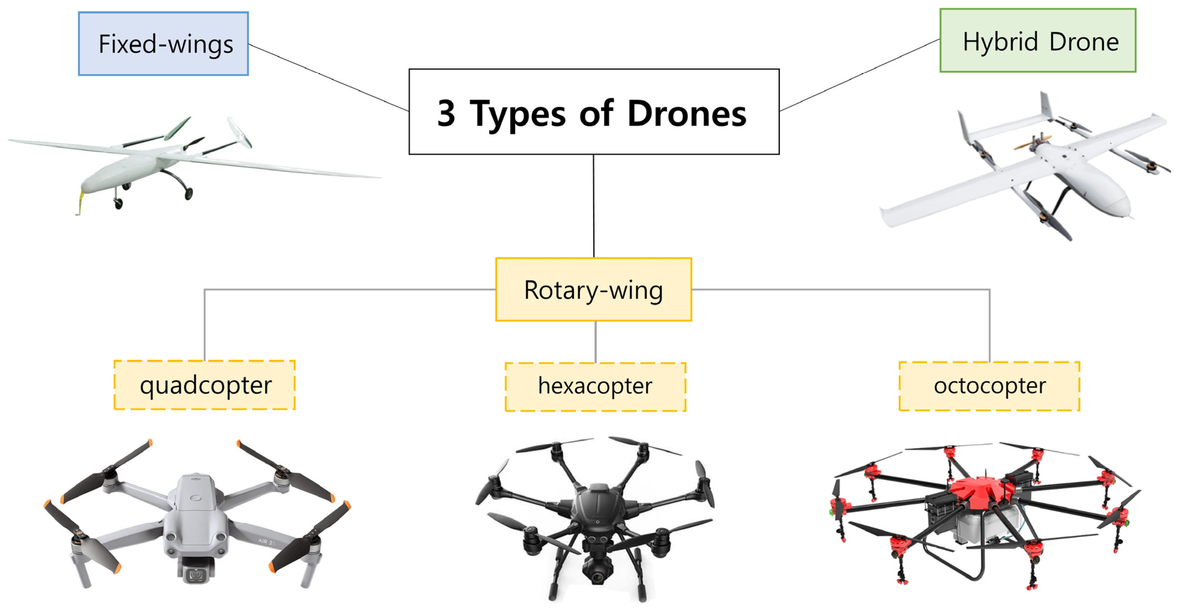
Classification by wings and rotors
| Category | Rotors/Wings | Advantage | Disadvantage | Price |
|---|---|---|---|---|
| Multi-rotor UAV | 2–8 | Availability, ease of use, good camera control | Lower efficiency in terms of energy consumption | 5,000–65,000 EUR |
| Single-rotor UAV | 1 | Ability to fly with heavy payloads | Requires a lot of maintenance, needs a pilot’s license | 25,000–300,000 EUR |
| Fixed-wing UAV | 1 | Covers greater distances, maps large areas, higher speed, energy efficient | Needs runway/catapult, higher cost, requires pilot training | 25,000–120,000 EUR |
| Fixed-wing hybrid VTOL UAV | >2 | Built-in autopilot, longer flight times | Few available on market, limited in both forward flight and hovering | >25,000 EUR |
Comparison of advantages and limitations of different flight systems
- Source:
| Aircraft type | Efficiency and range | Flexibility and maneuverability | Weather dependency | Payload | Safety | Complexity and simplicity | Running costs | Setup time |
|---|---|---|---|---|---|---|---|---|
| Airships | Very good | Average | Poor | Very good | Good | Good | Poor | Poor |
| Fixed wing aircraft | Very good | Poor | Good | Good | Average | Average | Average | Average |
| Helicopters | Average | Very good | Good | Very good | Poor | Poor | Average | Good |
| Multicopters | Poor | Very good | Good | Average | Average | Good | Very good | Very good |
Three types of drones and their applications
| Types of drones | Brief summary |
|---|---|
| Rotary-wing drones | Large-scale topographic surveys |
| Aerial inspections and monitoring of construction sites | |
| Capturing images in difficult weather | |
| UAV platform research | |
| Pilot’s expertise needs | |
| High initial cost of fixed-wing drones | |
| Fixed-wing drones | Detailed inspections available |
| Safe take-off and landing scenarios in case of failure | |
| Accessible for small-scale civil engineering projects or businesses with limited resources | |
| Limited flight time | |
| Structural issues impact quality and stability | |
| High-resolution mapping, limiting advanced data collection | |
| Hybrid drones | Benefits of long flights |
| Increase detailed data collection | |
| Designed with numerical simulations |
References
- Kovanič, Ľ., Topitzer, B., Peťovský, P., Blišťan, P., Gergeľová, M. B., & Blišťanová, M. (2023). Review of Photogrammetric and Lidar Applications of UAV. Applied Sciences, 13(11), 6732. https://doi.org/10.3390/app13116732
- Lee, S.; Choi, Y. Reviews of unmanned aerial vehicle (drone) technology trends and its applications in the mining industry. Geosystem Eng. 2016, 19, 197–204. Available online: https://www.tandfonline.com/doi/full/10.1080/12269328.2016.1162115
- Lyu, X.; Li, X.; Dang, D.; Dou, H.; Wang, K.; Lou, A. Unmanned Aerial Vehicle (UAV) Remote Sensing in Grassland Ecosystem Monitoring: A Systematic Review. Remote Sens. 2022, 14, 1096.
- Siebert, S., & Teizer, J. (2014). Mobile 3D mapping for surveying earthwork projects using an Unmanned Aerial Vehicle (UAV) system. Automation in construction, 41, 1-14.
- Choi, H.-W., Kim, H.-J., Kim, S.-K., & Na, W. S. (2023). An Overview of Drone Applications in the Construction Industry. Drones, 7(8), 515. https://doi.org/10.3390/drones7080515
#Drones #UAV #EASA #SwissDrones #DroneRegulations #FOCA #UASAirspace #DroneSafety
Subscribe and receive updates, lessons, courses and more. No spam!
Get the latest updates and tips.